93% of Miami Beach is a Flood Hazard Area, Are You Prepared?
Miami Beach is a beautiful coastal community. Our island is surrounded by the Atlantic Ocean and Biscayne Bay. Miami Beach is leading the way locally and nationally to reduce flood risk. We want you to be aware of flood risk due to our low-lying topography, extreme rainfall, annual king tides, and storms. It is our goal that all of Miami Beach − whether public roads or private homes − is in the best position possible before, during, and after potential flooding. We are all in this together.
Miami Beach is investing in public infrastructure to reduce flood risk associated with rainfall, storms, and sea level rise, and use the best available science to do so. The city is raising roads, installing new stormwater infrastructure, raising sea walls, creating higher elevation standards, and maintaining a healthy dune system.
Miami Beach is part of a unique partnership with Miami-Dade County and the City of Miami called Resilient Greater Miami and the Beaches. Greater Miami and the Beaches was selected to join 100 Resilient Cities, pioneered by the Rockefeller Foundation to address significant resilience issues- including planning and preparing for sea level rise and climate change. Resilience initiatives to prepare for sea level rise also help to reduce our current flood risk. Our program delivers the quality of life for residents and visitors today and provides for a sustainable and resilient tomorrow.
This Guide is your resource for learning about how to reduce your flood risk.
Coastal Cities Face a Major Flood Risk Due to Climate Change & Sea Level Rise
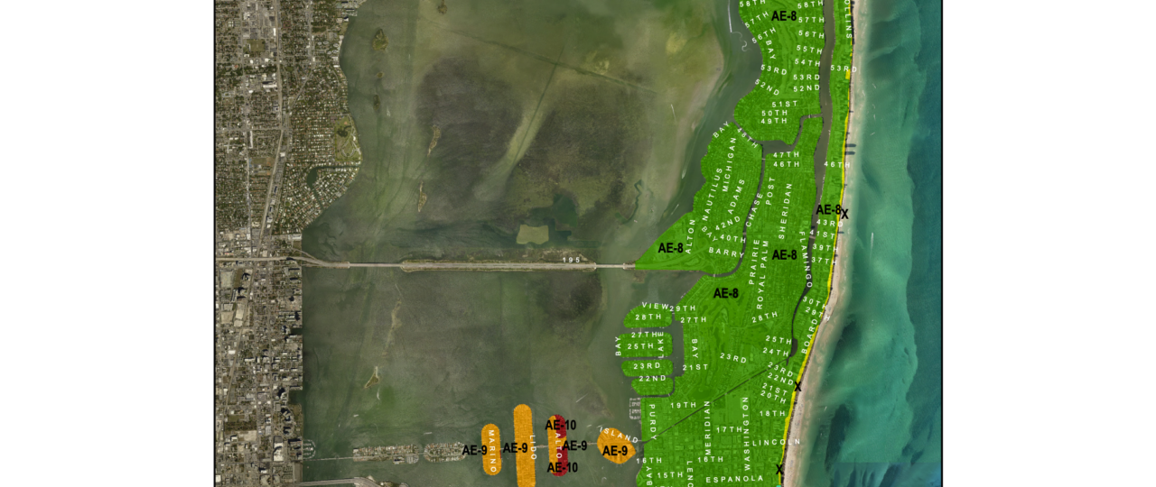
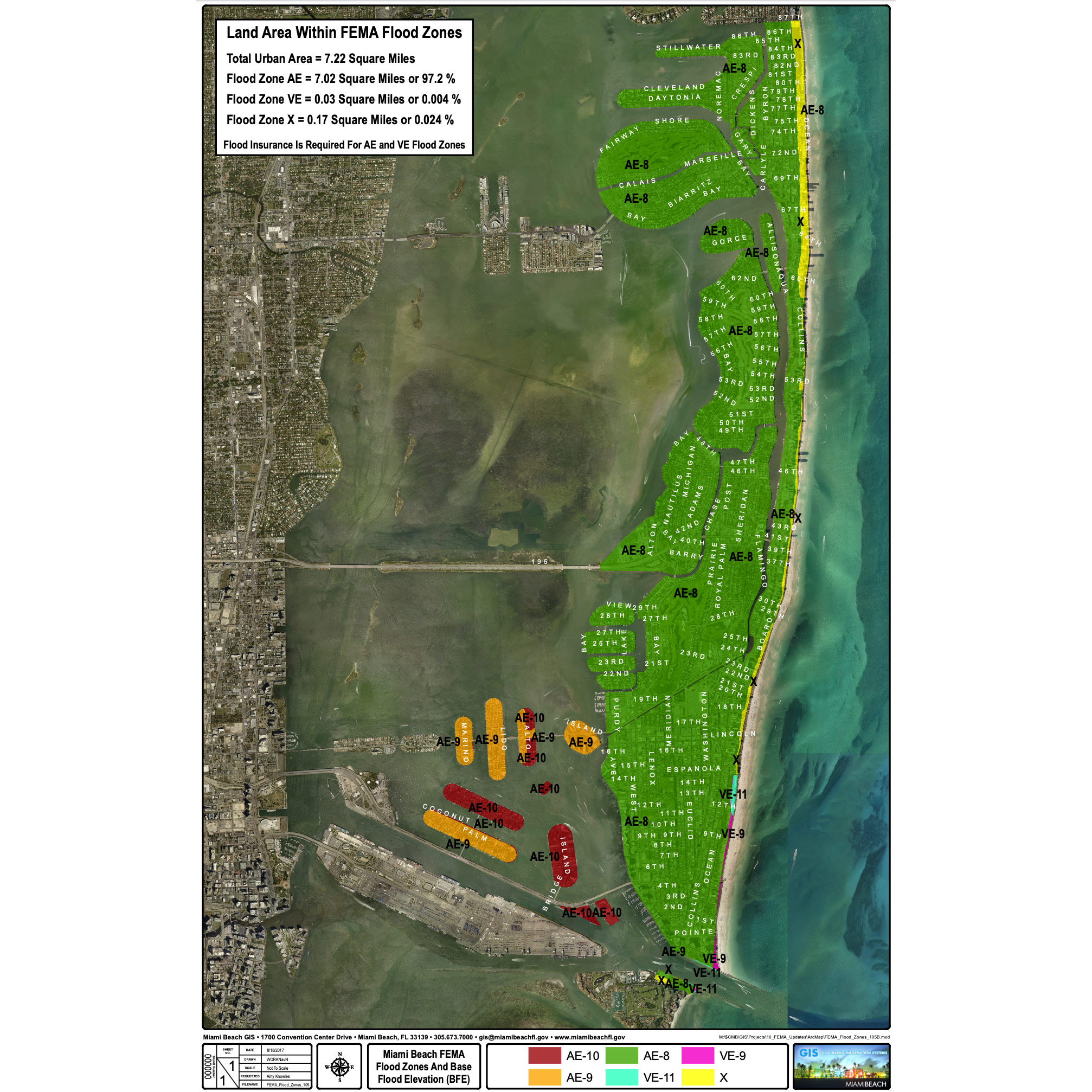
93% of buildings on Miami Beach are located in a Special Flood Hazard Area, as mapped by FEMA. Miami Beach is reducing risk by elevating roads, updating the stormwater system, and implementing new construction regulations to build higher.
FEMA’s detailed digital flood hazard maps reflect current flood risks for Miami Beach. The maps, also referred to as Flood Insurance Rate Maps (FIRMs), illustrate flood hazards throughout Miami-Dade County and are used when determining flood insurance policy rates. View the Flood Zone Maps using Miami-Dade County’s interactive web tool. Once you navigate to this web tool, enter your address to view the map for your area.
For confirmation of your property’s official flood zone designation, call 305.673.7610 or your insurance agent.
Protect Your Property with Flood Insurance
Flood insurance is required by federally backed mortgages, and recommended for all properties. The city saves you 20%, or $6 million dollars annually, in flood insurance premiums through top tier performance in the Community Rating System (CRS). For more information, visit Floodsmart.gov.
Homeowner’s insurance policies do not cover damages and losses due to flooding. The City of Miami Beach participates in the National Flood Insurance Program (NFIP) that makes flood insurance available to everyone in the city. We strongly urge you to buy flood insurance to protect yourself from a devastating loss. Information about flood insurance policies should be available to you through your insurance agent. Call your insurance agent now so that you will be prepared for future events. Do not wait for a disaster. Keep in mind there is a standard 30-day waiting period, from the date of purchase, before a new flood policy goes into effect.
If You See a Flood, Be Smart
Stay safe – avoid driving through or coming into contact with flood waters. Six inches of fast flowing water can knock you off your feet and less than a meter of water can float a car. Flood water can be contaminated with sewage or other pollutants. There could also be hazards below the surface, like debris, that you cannot see. Make sure you are tuned into Miami Beach social media and local weather alerts. South Florida can experience intense rainfall. Report any flooding to the city via the Miami Beach e-Gov app or by calling 305.604.CITY.
Keep Your Home Dry
There are many simple ways a homeowner can reduce the risk of flood damage. Consider elevating important appliances, like washers and dryers. Choose materials such as tile flooring as opposed to wood, that are resistant to water damage. You can also redirect rain and flood waters through techniques like elevated driveway edges. If you lease your property or business, we recommend discussing your flood protection options with your landlord or property owner.
Build Resiliently & Know Your Elevation
If you are considering renovation, build resiliently and sustainably! Follow the Florida Building Code and the City of Miami Beach Code to reduce your flood risk. We suggest contacting a professional architect or engineer for advice on how to integrate resilience, sustainability, and flood protection into your design. The city participates in the Property Assessed Clean Energy (PACE) program. PACE is a financial platform that eliminates the barrier of high upfront costs by allowing property owners to pay off energy efficient and storm mitigation home improvements through an assessment on their property tax bill.
An Elevation Certificate is an important document that every homeowner should have, and in case of a disaster, would demonstrate local authorities that your house is at or above the required elevation. An elevation certificate will not only tell you how high your house was built in relation to that flood zone, but can potentially lower your insurance premiums. Miami Beach has been collecting the Federal Emergency Management Agency (FEMA) Elevation Certificate that is prepared by a professional land surveyor on behalf of home builders/developers since 1995 as they are required for all new construction and substantial improvements to a structure. For a list of addresses with available elevation certificates, visit miamibeachfl.gov and select Flood Awareness in the Quick Links.
If the elevation certificate shows that the lowest floor of your house is lower than the required flood design elevation, then the substantial improvement ̏50% rule” would apply to your house. This rule means that if your house is in a flood zone and is damaged and/or improved to an amount greater than 50% of its building market value, the lowest floor will have to be raised to meet the current elevation requirement.
Protect & Preserve Our Environment
Beach dunes and vegetation, coral reefs, and green open areas are natural flood barriers. Open green space helps flood waters drain.
Beach dunes and coral reefs serve as the first line of coastal defense by buffering wave energy, blocking storm surge, and protecting coastal infrastructure. Open green space and natural low-lying areas can help with drainage. Landscaping can be designed to flood during rain events or high tides.
Have a Plan
Flooding can range from being unexpected, like a fast and heavy rainfall, to being known and communicated in advance, such as in the case of King Tides and hurricanes. Weather can be unpredictable. Thinking ahead can keep you safe and reduce damage to your property. Think about having sand bags ready, putting up flood panels, adjusting your work schedule if possible, parking your car in a higher location, and wearing rain boots if you must be out in the elements. Most of all, many times it is best to stay put and give the stormwater system time to drain the water. At the start of hurricane season, June 1st, visit www.miamibeachfl.gov, review our Hurricane Guide, and develop a plan for these more significant events.
Keep it Clean!
Don’t litter! Keep storm drains clear of litter and debris to prevent flooding and keep Biscayne Bay clean. Report issues to the free Miami Beach e-Gov app or call 305.604.CITY.
Financial Assistance
Relief is available for properties that have experienced damage. Learn more by contacting the Grants Office at 305.673.7510.
Miami Beach is There to Help You
The Building Department offers free technical assistance to identify ways to reduce flood hazards. Call 305.673.7610 to learn more.
MIAMI BEACH & THE NATIONAL FLOOD INSURANCE PROGRAM (NFIP)
HOW VULNERABLE IS MIAMI BEACH TO FLOODING AND HOW DOES THIS IMPACT INSURANCE COVERAGE?
- The City of Miami Beach participates in the National Flood Insurance Program (NFIP). Due to this, flood insurance is available to building owners and renters.
- Nearly all of Miami Beach is located in or near a Special Flood Hazard Area detailed in Flood Insurance Rate Maps (FIRM).
- 93% of the buildings are located in the Special Flood Hazard Area, which means insurance is required for buildings with federally backed mortgages. The remaining 7% are encouraged to carry insurance, being so close to the hazard.
- 84% of buildings on Miami Beach carry flood insurance policies under the National Flood Insurance Program. Some buildings do carry additional private insurance – since the coverage limits are quite low in comparison to the high values of many Miami
Beach homes (coverage is $250,000 for a single-family home). - 64% of NFIP policies are held by buildings that are Pre-FIRM, meaning they were constructed before the first FEMA Flood Insurance Rate Maps in 1972.
- Pre-FIRM buildings pay less than the true cost of risk because they are subsidized.
- Most Pre-FIRM buildings on Miami Beach are lower than Base Flood Elevation (BFE).
- For a single-family home, if the building’s lowest livable floor elevation is higher than BFE+2 ft, then the premiums could be cheaper than the subsidized rate.
- 36% of NFIP policies are held by buildings that are post-FIRM, meaning they were constructed after the first FEMA Flood Insurance Rate Maps in 1972.
- In 1994, Miami Beach became an NFIP community. Most homes built after 1994 have elevation BFE+ (higher than FEMA Base Flood Elevation).
- However, commercial buildings are less likely to be BFE+.
FEMA MODELING AND MAPS
- The current FIRM maps that are in effect for Miami Beach were adopted in 2009.
- FIRMs only evaluate risk based on the modeling – they do not use projections from sea level rise or proposed construction to reduce risk.
- The city will make sure that FEMA has the best and latest available data on newly elevated roads before the maps are finalized.
- Current modeling is underway
- In 2018, FEMA will provide a draft work map to the city that will include what they think the FIRM will look like.
- In 2019, FEMA will provide preliminary maps, with an 18-month process for these to become effective. We do have the ability to provide new completed road elevations during the preliminary map phase in 2019.
- In 2021, FEMA estimates that final maps will be effective.
- Appeals process – we will be engaged, for a 90-day period where FEMA will accept appeals and comments. At the end, FEMA will evaluate and incorporate or advise. Appeals can come from property owner, local jurisdiction, or neighborhood.
WILL ELEVATING ROADS IMPACT FLOOD INSURANCE?
According to FEMA and the city’s Floodplain Manager, elevating roadways and improving storm water drainage in Miami Beach will not negatively impact private property flood insurance. Road elevation is not part of the flood insurance criteria. This question can best be answered in two-parts.
1. Elevating roadways is one of many positive steps a community can take to mitigate risks and increase their resilience to natural hazards.
There are conditions that can make a building uninsurable by the National Flood Insurance Program. Elevating public roads and improving storm water drainage do not create these conditions.
2. FEMA modeling and elevating the roads may impact the future FEMA Flood Zone Maps
Once completed, the elevations associated with the roadways can be taken into account in modeling applied to FEMA’s Flood Insurance Rate Maps (FIRM), potentially changing modeling results that support the hazards depicted on the maps.
Currently, FEMA is updating these maps in Miami-Dade County, including the City of Miami Beach. Completed work will be incorporated, as possible, into the ongoing modeling. Future changes, or changes unable to be incorporated due to timing issues, can be incorporated through the FEMA Letter of Map Change process. Any change in Base Flood Elevation on personal property, regardless of its origin, will impact the flood insurance rating, which is done on an individual structure basis taking into consideration a number of flood risk factors. The city will make sure that FEMA has the best and latest available data before the maps are finalized.
Existing maps are located here: Miami Beach Flood Zone Map
WHAT IS THE CITY DOING TO REDUCE YOUR PERSONAL FLOOD INSURANCE PREMIUMS?
The city participates in the National Flood Insurance Program Community Rating System. Our score currently saves residents 20% on their flood insurance premiums – an estimated $6 million annually.
The National Flood Insurance Program rates are governed federal legislation. For the most recent information about your property and building type, speak to your flood insurance agent and visit www.fema.gov/flood-insurance-reform. The most effective way to reduce the cost of flood insurance in Miami Beach is for the lowest livable floor of a property to be above the FEMA Base Flood Elevation (BFE).
INTERESTED IN RESILIENT CONSTRUCTION ON MIAMI BEACH?
Elevate, Elevate, Elevate! Reduce your risk of damage from flooding – and save money on flood insurance also.
- Build higher than FEMA requires. Miami Beach requires new construction to be more than one to five feet higher than Base Flood Elevation.
- Elevate important appliances, like air conditioning, water heater, and washers and dryers.
- Elevate electrical plugs to a higher location higher on walls.
- Redirect rain and flood waters through techniques like elevated driveway edges.
Build responsibly
- If your project will be reviewed by any of the four land use boards, contact the Planning Department to discuss resiliency review criteria.
- Miami Beach requires LEED Gold or Living Building Challenge Certification for certain new construction.
- Choose construction materials that are resistant to water damage below base flood elevation, such as tile flooring and cement instead of wood.
- Permits are required – follow all Florida Building Code and Miami Beach Codes to make sure you are meeting all requirements.
- Insert flood openings in areas such as garages and lobbies, to allow the flow of water in the event of flooding. This can lower your cost of flood insurance.
- Obtain an elevation certificate when the lowest floor slab is poured and prior to obtaining a final building inspection approval to ensure the lowest
finished floor elevation is elevated at or above the Design Flood Elevation. - Provide positive and adequate drainage away from the structures and prevent flooding the neighbor properties.
Protect natural floodplain functions
- Integrate salt tolerant vegetation and green open areas as they are natural flood barriers. Open green space helps flood waters drain.
Have a plan! South Florida will experience flooding from storms, hurricanes and King Tides.
- Have a storm, hurricane and King Tides plan.
- Follow Miami-Dade Municipal Code to secure the construction site. Fasten down or remove hazardous objects.
- Know evacuation routes. See http://www.miamidade.gov/hurricane/.
- Park your car in an elevated garage floor.
Technical Assistance:
- Building Department and Floodplain Management staff can provide you information on flood zone determination, Florida Building Code, flood damage prevention regulations and requirements, 50% rule and FEMA retrofitting technique guides. Please contact the Building Department at 305.673.7610.
Do you Own Property in Miami Beach?
If you are considering renovation, build resiliently and sustainably! You will need to follow the Florida Building Code and the City of Miami Beach Code. We suggest you contact a professional architect or engineer for advice on how to integrate resilience, sustainability, and flood protection into your design. The city also participates in the PACE program, a way to finance sustainability improvements for home renovations.
Considering new landscaping with your new home? Choosing “Florida Friendly” is wise – helping to protect the environment, birds, bees, and butterflies! Florida Friendly Plants Guide: http://fyn.ifas.ufl.edu
The city participates in the National Flood Insurance Program Community Rating System. Our Community Rating System (CRS) score currently saves residents and businesses up to 20% on their flood insurance premiums – an estimated $6 million annually. For more information about flood insurance rates, we advise you to contact your flood insurance agent and visit Floodsmart.gov.
WHY DOES MIAMI BEACH HAVE FLOODING CHALLENGES?
- It is difficult to drain a city that is an island, flat, and only a few feet above sea level in many places. Since we are flat, we lack the energy for drainage created by gravity, and water drains slowly.
- Miami Beach’s hydrology makes draining rainwater difficult. We have a high groundwater table that reduces the ground’s ability to absorb rainwater. In addition, the subsurface is porous limestone, and is affected by the surrounding Bay and Ocean water.
- Many of our outfalls are tidally influenced. An outfall is the location where the stormwater exits the system to a water body. This means the higher the tide, the more slowly stormwater can drain.
- Miami Beach is densely populated. At only 7 square miles, we lack large open spaces, such as wetlands, to drain rainwater. Impervious surfaces, hard surfaces like concrete, do not allow rain to soak in. These surfaces contribute to the amount of runoff and how fast the runoff travels to the collection system.
- If all rain was slow and gentle, we would be less at risk for flooding. However, all rain storms are different.
HOW DOES STORMWATER DRAIN? WHAT ABOUT PUMPS?
- Rain falls to the ground and runs off impervious surfaces. Stormwater flows across the land, over parking lots, through swales, down ditches, along gutters, and eventually makes its way to storm grates.
- Stormwater flows into storm grates and is collected in a basin.
- Stormwater flows from catch basin into the system of stormwater pipes.
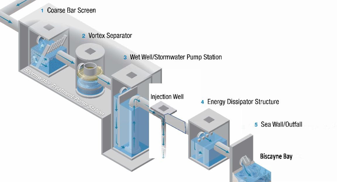
- Stormwater flows through conveyance system to the outfall. Miami Beach is now moving to a system of pumps to more quickly and effectively drain the water to the outfalls.
Miami Beach Stormwater Pump System:
Coarse Bar Screen
Vortex Separator
Wet Well/Stormwater Pump Station
Injection Well
Energy Dissipator Structure
Sea Wall/Outfall
Biscayne Bay
Each of these steps requires an amount of time to accomplish, so no matter how a system is designed, draining an area of land can never be instantaneous. Each of these four steps offers an opportunity for a bottleneck to develop and slow down the whole process. If the rain falls at a faster rate than any one of the steps can accommodate, the system will back up and ponding (standing water) will occur.
For practicality and cost-effectiveness, new stormwater collection systems are designed to accommodate the runoff from a rain event of a certain intensity and duration, called the design storm. Any rain event larger than the design storm will cause the system to back up. The flatter the land, the slower the water will move, and the more time it will take to drain an area of land.
We are all in this together. Miami Beach is installing a new stormwater collection system and pumps to reduce the risk of flooding. This is an ambitious program, with construction planned over the next ten-years, and we are leading the way locally and nationally.
MIAMI BEACH KING TIDES:

King tides are the highest and most extreme tides of the year. Gravitational forces and the alignment of the sun and moon cause the tides to change throughout the year. Since King Tides can cause flooding, it’s important to have flood insurance and stay safe.
WHAT ARE KING TIDES?
The King Tide is the highest predicted high tide of the year. During this period, water levels are higher than that on an average day. In Miami Beach, the king tides usually occur during the months of September, October, and November. King tides provide a preview of the normal tidal variations we will see in the years to come as sea levels continue to rise.
HOW ARE KING TIDES PREDICTED?
In the United States, tides are predicted by the National Oceanic and Atmospheric Administration (NOAA). The NOAA Tides and Currents station map can be used to locate stations that provide water levels, meteorological observations and current observations. The Virginia Key station is the closest NOAA Monitoring Site. The city has also deployed two tide gauges to monitor tides.
WHAT CAN INFLUENCE THE TIDES?
The relative distances and positions of the sun, moon and Earth all affect the size and magnitude of the Earth’s two tidal bulges. On a smaller scale, the magnitude of tides can be influenced by the shape of the shoreline and the gulfstream current. According to the NOAA Ocean Service Education local wind and weather patterns can also affect tides. King tides can reach over 12 inches above the average high tide for the year.