Map of the Best Places to Live in Miami and Miami Beach
South Florida is one of the most popular places in the entire country to move to, and almost every one of those people who are moving here are asking me “Where are the best places to live in Miami?”. Thankfully there’s a great interactive map that was created to answer that question!
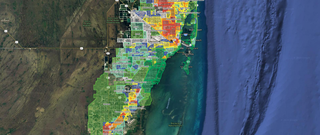
City-Data user ‘Jacobmax‘ has created a very useful interactive Map of the Best Places to Live in Miami and Miami Beach called the ‘Miami Neighborhood-O-Meter’. The interactive map (below, with key) includes all of the neighborhoods and cities in Miami-Dade county, rated by quality of life (safety, crime, poverty, upkeep, amenities, reputability, etc.). The Map of the Best Places to Live in Miami and Miami Beach is color coded by neighborhood, with the best areas labeled in dark green color, and the worst areas labeled in red color (there is a complete key to this map at the end of this page). The creator of the map used factual government & public data, his own research, and ongoing community feedback to come up with the interactive map of Miami located below, and it’s updated regularly as Miami neighborhoods change.
The full size interactive map is below. You can zoom in & out, and click on any neighborhood to see the neighborhood name.
Interactive Map of the Best Places to Live in Miami
Map Key:
Dark Green – Very nice, perfectly maintained, very safe.
Standard Green – Quite nice, very maintained, quite safe.
Light Green – Above average areas, mostly maintained, mostly well-kept and safe.
Purple – Decent areas, decently maintained, partially safe.
Light Blue – Mostly Non-Residential Areas – Neutral/Variable.
Yellow – Below average areas, below average maintained, partially/mostly unsafe.
Orange – Mostly bad areas, poorly maintained, unsafe.
Red – Bad areas, very unsafe.