The Ecology and History of Biscayne Bay
Biscayne Bay is a shallow saline tropical bay located along the southeastern coast of Florida. It is bordered to the west by the mainland of Florida, which includes the densely populated areas of Miami-Dade County. To the east the Bay is bordered by a series of barrier islands and the northern Florida Keys. The Bay is connected to the Atlantic Ocean by a series of channels and cuts, some natural and some manmade, and it contains a number of islands, the majority of which are manmade.
Biscayne Bay was formed as rising sea level filled a limestone depression. It is not a drowned river valley like most estuaries. Unlike other estuaries, the Bay does not receive a sediment load from major river systems. Most sediments in the Bay are produced by local biota.
The Biscayne Bay system can be divided in three major areas. The North Bay area extends south from Broward County to Rickenbacker Causeway, constituting approximately 10% of the total Bay area. Of the numerous islands in this part of the bay, only Belle Isle and Virginia Key are natural. The area is heavily populated, with most of the shoreline bulkheaded and the majority of the bottom dredged. Major tributaries to North Bay include Arch Creek, the Biscayne Canal, Little River and Miami River, and tidal exchange with the Atlantic ocean occurs at Bakers Haulover Cut, Government Cut and Norris Cut.
The Central Bay ranges from Rickenbacker Causeway south to the boundary of Featherbed Bank just north of Sands Key. Tidal exchange occurs through the Safety Valve, a series of shoals which make up the eastern boundary of this part of the Bay. The Coral Gables Waterway, Snapper Creek and Cutler Drain are the main tributaries to this section. Development along the coastline is not as pronounced in this section, so much of the natural mangrove wetlands are still intact along with large seagrass beds and small areas of soft coral and sponges. Chicken Key and Soldier Key are the only natural islands.
South Bay extends from the Featherbed Bank to Card Bank. Largely undeveloped, the area is fringed by mangrove wetlands, with dense seagrass beds, large hard ground areas and algal communities. Black Creek, Princeton Canal, Military Canal, Mowry Canal and Model Land Canal drain into this part of the Bay, with restricted tidal exchange through Broad Creek, Caesar’s Creek, Angelfish Creek and between the northern Florida Keys. The southern end of the Bay is connected by restricted openings to Card Sound, with limited exchange between the two. There are a number of natural keys in this part of the Bay as well.
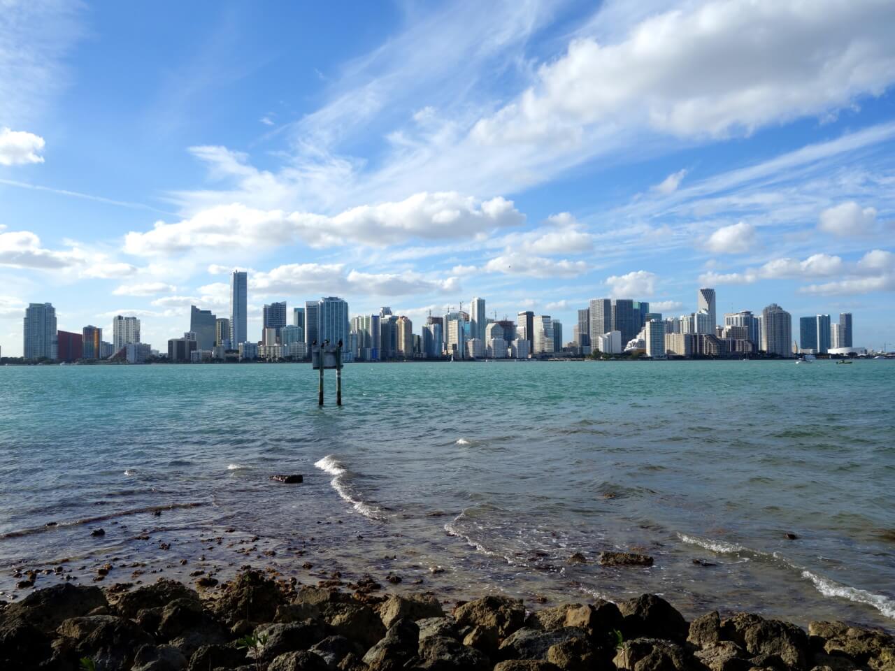
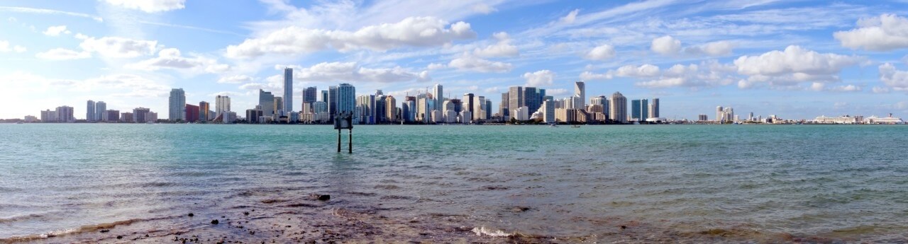
Biscayne Bay looking towards Miami from Virginia Key
History of Biscayne Bay:
Although the environment of Biscayne Bay has changed considerably over the past two centuries, prior to the mass urbanization at the beginning of the 20th century all major changes to the Bay were due to natural forces such as hurricanes. A 1770 chart shows a continuous barrier island encompassing what is now Miami Beach. A hurricane formed Norris Cut in 1835.
During the early 1900’s, the population in South Florida was small, only about 40,000. Most were dependent upon the Bay for survival as agriculture was limited. Members of the Seminole Indian tribe frequently traveled down the Miami River to the Bay and camped on the banks. “Miami” is the Seminole word for “sweet water”, and the freshwater springs in the river and bay were one of the features of the area.
In 1896, Henry Flagler decided to extend his Florida East Coast Railway to Miami, hoping to attract northerners to the mild, warm climate. Flagler built the Royal Palm Hotel on Brickell Point the following year. Miami began to grow and the city was incorporated. As the population increased, so did the need for dry land, and beginning in 1903 canals were dug to drain the coastal wetlands. The rapids of the Miami River that were located near today’s 27th Ave. were dynamited in 1908. Advertisement about the City of Miami led to over 10,000 people being turned away from the hotels in 1917 & 1918. The sharply accelerated growth in the Miami area continued until the 1920’s. Lack of protective legislation permitted wholesale shoreline and mangrove destruction, and construction of canals, channels, cuts and bridges. Dredge material from the channels and cuts was used to create artificial islands and destroyed or damaged large areas of Bay bottom.
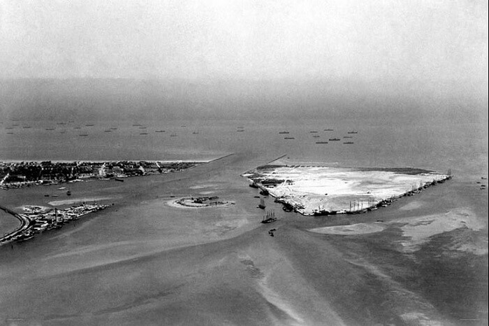
Government Cut, Fisher Island, and Terminal Island in a rare photo from 1915
The Port at that time was located in the Miami River and could only be reached by the channel around Cape Florida. Government Cut was constructed in 1902 to provide a more direct route. The dredge spoil was used to create Dodge Island, Lummus Island, as well as Fisher Island. Tidal flow through the new cut caused beach erosion on Virginia Key and Key Biscayne. The first bridge to Miami Beach was constructed in 1913, and Carl Fisher began development of the beachside area as a resort, destroying the mangrove forests and installing bulkheads. Star Island was the first true fill island constructed by bulkheading an open water area.
Star Island, Palm Island, and Hibiscus Island, in Miami Beach with the brand new Venetian Islands in the background
The land boom of the 1920’s brought the continuation of considerable development to Miami and Miami Beach. “Water acreage” was often sold before islands were even built. The Venetian Islands were built in rapid succession, but plans for expansion were thwarted by objections to “further mutilation of the waterway”, the land boom bust, a hurricane, and the onset of the Depression. The Intracoastal Waterway, Bakers Haulover Cut, and the 79th Street Causeway were all constructed in the mid 1920’s. The Hurricane of 1926 was rated a category 4 on the Saffir/Simpson scale, and the 300,000 people in South Florida were totally unprepared. News of the devastation destroyed South Florida’s image as a tropical paradise, dramatically slowing the pace of development. More than 75% of the land between Broad and Rickenbacker Causeways had been developed, and 75% of the bay bottom from Venetian to MacArthur Causeway had been dredged or disturbed before 1930. This damage would continue to affect the Bay until the present.
Biscayne Bay topography showed little change in the 1930’s, except for the construction of a few more spoil islands. Sea level began to rise during this time, and bacterial pollution was found from Tahiti Beach to North Bay. The pollution was traced to the City of Miami, where 59 sewers emptied untreated, raw waste into the Bay and Miami River.
The 1940’s and World War II improved the Miami area economy, although most coastal water activity ceased due to the presence of German submarines just off the coast. Homestead Air Force base was built during the war.
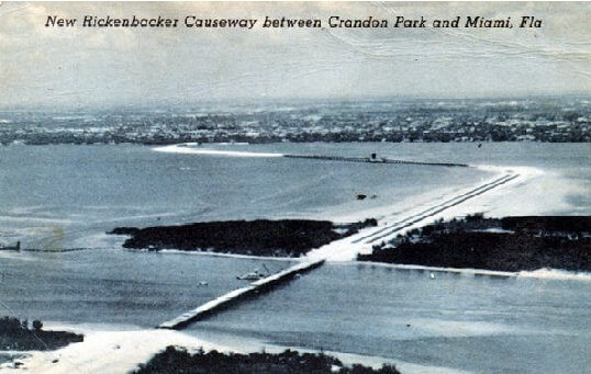
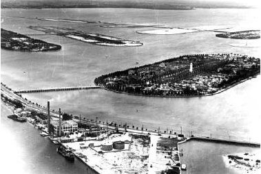
Rickenbacker Causeway and the Bay Harbor Islands
Rickenbacker Causeway and the Bay Harbor Islands were built in 1943, and several parks were created, including Crandon Park, Cape Florida State Recreational Area, Biscayne National Park and Everglades National Park. Environmental conditions in the Bay continued to deteriorate, as the Bay was constantly fouled with sewage and suspended material. A faunal shift due to change from euhaline to polyhaline conditions occurred in Manatee Bay. Decline in fish, crab, and coral was noted as well. Public outcry finally led to the construction of the Virginia Key sewage plant, and public raw sewage outfalls were capped. Saltwater intrusion became significant at this time, and salinity control dams were installed in most Miami canals in 1945.
Population increase in the 1950’s meant continued urban expansion. Broad Causeway was constructed in 1951, resulting in restricted tidal exchange to North Bay. Dodge Island was chosen as the site of new Port facilities in 1959, and construction began soon thereafter. During the 1950s, the number of outfalls was reduced and the level of coliform bacteria in Biscayne Bay waters declined. Populations of benthic macroinvertebrates in the area near the City of Miami and the Miami River declined from abnormally large numbers of species and individuals to normal numbers of each. In hard sandy bottoms adjacent to outfalls, numbers of species and numbers of individuals increased. In poorly flushed waters, volumes of zooplankton decreased to about one-half the pre-abatement values. Abundance of amphipod tubes declined. Populations of other fouling organisms remained about the same. There was no evidence of improved commercial and sports fishing. Surveys of the North Bay in 1954-57 and 1959 showed the area to be almost totally devoid of attached benthic life. Fishing in the area was minimal. The waters of the ship basins were found to be traps for the collection and sinking of debris and garbage.
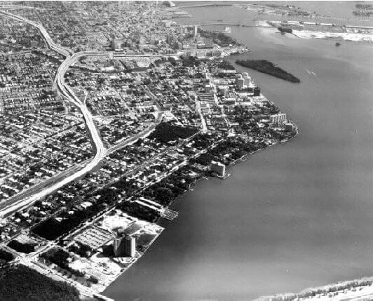
Aerial view of Miami in 1969, note the undeveloped Brickell Key.
Urban development continued into the 1960’s. The Julia Tuttle Causeway was built in 1961, further restricting circulation in North Bay. The fill borrow pit, just north of the causeway, was 29 feet deep. The Dodge Island Seaport officially opened in 1964 when port operations were moved from the old site in Biscayne Blvd. Port activity continued to increase as cruise lines used the Port as a base of operation. Hurricanes Donna, Cleo and Betsy passed near or over Biscayne Bay.
In 1974, the Biscayne Bay Ecology Committee organized a symposium on the status of the Bay and the papers published in the proceedings are a synthesis of the physical, geological and biological processes, and man’s uses and interaction with the Bay. The last major change to North Bay took place with the expansion of the Port of Miami onto Lummus Island. In 1974, the Florida State Legislature enacted a law designating Biscayne Bay as an aquatic preserve, placing stringent controls on further development in the Bay area. The nuclear units of the Florida Power and Light Turkey Point Power Plant in South Bay began operations in 1972, giving researchers an opportunity to study the effects of thermal pollution on the bay. Pollution inputs to the Bay during the 1970s were attributed to runoff from the urban areas and continuing sewage pollution. Teas et al. (1976) studied changes in shore vegetation up to the 1970s at five sites: Interama, Cocoplum, Saga, a section south of Black Point, and Card Point. Shore vegetation had been eliminated in most of the northern Bay and seriously impacted elsewhere. Sick and deformed fish were caught in Biscayne Bay.
During the 1980s, fine suspended material was identified as a major problem in Biscayne Bay. Steps were taken to reduce the suspended material, and the amount of suspended solids decreased in the Bay from 1979 to 1983. However, initial efforts to restore seagrasses failed due to high turbidity. The only parts of North Bay that appeared healthy were flushed with ocean water from Bakers Haulover Cut, and Julia Tuttle Causeway. The most turbid water was found between the 79th Street and Broad Causeways. Development of Brickell Key began at this time. Scientists found high concentrations of hydrocarbons in the sediments of Biscayne Bay, Little River, the Miami River, Black Creek and Military Canal in 1982-1983.
The 1990’s are marked by the passage of Hurricane Andrew, the category 4 storm which passed directly over Biscayne Bay in August of 1992. The dramatic removal of exotic vegetation by the storm presented a unique opportunity to replant with native species. As of 1995, one million mangrove trees were planted on the shores of Biscayne Bay and 100 acres of wetlands were restored or created. Fishing improved in Biscayne Bay during the 1990s perhaps due to reduction of contaminant input, above-average rainfall reducing the salinity, and the statewide ban on coastal net fishing protecting game-fish and bait established in 1995. Fishermen reported clearer waters in the northern Bay.
Flora and Fauna
The flora of Biscayne bay is dominated by seagrass beds and mangrove communities. The major seagrasses found in Biscayne Bay are Thalassia testudinum (turtle grass), Halodule wrightii (Cuban shoal grass), and Syringodium filiforme (manatee grass). These plants function as a food source, provide shelter and protection, stabilize sediments, and act as a chemical sink. There is a progression of these seagrasses with distance from shore in non-disturbed areas of Biscayne Bay. There is a band of Halodule intertidally and a band of Thalassia sublittoral interspersed with Halodule and Syringodium, thinning out into green alga and a sand bottom towards mid-Bay. Seagrasses in the northern part of the Bay have been heavily impacted and normal communities are not observed north of the Port of Miami. Efforts to mitigate seagrass beds have met with mixed results. The effect of the thermal effluent released by the Turkey Point Nuclear Power Plant on Thalassia beds has been studied extensively. Thalassia disappeared in areas of water 5ø C above ambient, and declined by 50% in waters 3-4ø C above ambient temperature. Environmental stress caused by temperature or salinity changes may make Thalassia more susceptible to disease. An increasing problem in Biscayne Bay is the scarring of seagrass beds caused by boat propellers. The greatest scarring damage has occurred in areas of dense human population with approximately 6% of the seagrass beds in Dade County having moderate to severe scarring.
Grounding and prop scars in Biscayne Bay near South Beach
The most common mangrove species in the Biscayne Bay area are the red mangrove (Rhizophora mangle); the black mangrove (Avicennia germinans); the white mangrove (Laguncularia racemosa); and the buttonwood (Conocarpus erectus). The red mangrove, with its thick mass of prop roots, is particularly well established in the substrate, and only the most violent of hurricanes can disturb it. It forms a protective barrier along the coast, behind which the other mangroves and associated flora take root. Accumulation of sand, leaves, and debris in the mangrove forest eventually raises soil levels. The result is a gradual land building and seaward extension of the coastline. For most of Biscayne Bay’s history, mangrove forests in Florida were regarded as a wasteland suited only for development. However, these forests contribute in many ways to man’s economic betterment. Ninety-five percent of the annual mangrove leaf production eventually enters the aquatic system as detritus, which is the basis of the estuarine food chain. A number of commercially valuable species rely on the mangrove swamp as a nursery and feeding ground. Mangroves along Biscayne Bay can be classified into five communities: Coastal Band, Dense Scrub, Sparse Scrub, White and Mixed, and Black Marsh. The Coastal Band of mature mangroves along the shore is the most productive, and the dwarfed Sparse Scrub the least. During the last few years, mangrove die-offs have been observed, first in black mangroves and currently in red mangroves at lower elevations. There is a rough correlation with seagrass die-offs suggesting possible correlation to high salinities. Changes in precipitation and runoff are the most important factors concerning mangrove survival. In addition to changes in mangrove ecosystems due to climatic factors, mangrove forests along the shores of Biscayne Bay were destroyed beginning in the 1910s as the result of urbanization, including the construction of the drainage canal system, which altered the hydrology of the Bay area.
Up until the 1940s, the Biscayne Bay sponge fishery was one of the most valuable fisheries in Florida. A combination of disease, heavy harvesting, and the introduction of synthetic sponges has reduced the industry to a small fraction of its former importance. Currently, highest sponge densities occur in Biscayne Bay in hard bottom areas with moderate currents, constant salinity, low sedimentation, shallow, coarse sediments and sparse vegetation. The highest densities are in a north-south cluster in Central Bay. Biscayne Bay was closed to commercial sponging in 1991. Biscayne Bay to is an important refuge for juvenile spiny lobster (Panulirus argus) and a large portion of the Bay is designated as a Lobster Sanctuary.
Many species of birds are found in Biscayne Bay, some are permanent residents while others use the Bay as a resting area during migration. Major bird rookeries include Bird Key, Chicken Key, Biscayne National Park, Key Biscayne, Virginia Key, and the mangrove islands in North Bay.
Crocodiles are an endangered species throughout their range in South Florida which includes Biscayne Bay, Card Sound and Barnes Sound. The population represents a large part of the breeding individuals in the US. Nesting sites in Miami Beach and the upper Florida Keys have been lost to development, although the loss has been compensated by the creation of artificial nesting sites on spoil banks along the cooling canals of southern Biscayne Bay.
The Florida, or West Indian manatee (Trichechus manatus latirostris) is regarded as a regional subspecies. Manatees are herbivores, feeding on aquatic plants, and they require freshwater sources, proximity to channels 3 to 8 feet deep, and access to warm water during the winter. Manatees are found along most of the coast of Florida. During the winter, they migrate to warmer waters and are known to congregate in natural or industrial warm water sources. Concern for the survival of the manatee in Florida was recognized as early as the 1700’s when the English Crown established all of Florida as a manatee refuge. By 1893, the State of Florida passed laws prohibiting the capture or killing of a manatee without a permit. The manatee was listed an endangered species in 1967 and thus came under the protection of the Endangered Species Preservation Act of 1966. A series of subsequent legislative actions to protect endangered species, including the manatee, took place and by the 1970s US Fish and Wildlife Service organized a Recovery Team to prepare an overall recovery plan for manatee. Central to conservation efforts has been the successful marketing of the manatee image to the extent that they evoke sympathy and support from the legislators, the media and the public. Manatees continue to suffer a high degree of human induced mortality and injury, usually the result of wounds caused by boat propellers. Biscayne Bay is a Federally Designated Critical Habitat for the Florida manatee, with a winter population of 80 to 100. More than 80 mortalities in Dade County between 1974 and 1993 were caused by human activities.
Restoration, Mitigation, and Management Efforts
Since the 1940’s, a significant amount of Federal Legislation has been passed to protect the environment, with many affecting in some way the Biscayne Bay area. This legislation includes:
The Federal Water Pollution Control Act (FWPCA), originally enacted on June 30, 1948 (Publication 845, 62 Stat. 1155).
The Clean Air Act (CAA), also called the Air Pollution Control Act (Public Law 159, 69 Stat. 322), originally enacted on July 14, 1955.
The Toxic Substances Control Act (TSCA) (Public Law 94-469, 90 Stat. 2003), originally enacted on October 11, 1978.
The Federal Insecticide, Fungicide and Rodenticide Act (FIFRA) 1947 (Public Law 102, 61 Stat. 163), originally enacted on June 25,.
The Resource Conservation and Recovery Act of 1976 (RCRA) (Public Law 94-580, 90 Stat. 2795), also known as the Solid Waste Disposal Act, enacted on October 21, 1976.
The Comprehensive Environmental Response, Compensation, and Liability Act (CERCLA) (Public Law 96-510, 94 Stat. 2767), also known as the Superfund Act, enacted on December 11,1980.
The Emergency Planning and Community Right-to-Know Act of 1986 (EPCRKA).
The Endangered Species Act (ESA) (Public Law 93-205, 87 Stat. 884), approved on December 28, 1973.
The National Marine Sanctuaries Act (Public Law 95-532, Title III, 86 Stat. 1061), approved on October 23, 1972.
The Marine Mammal Protection Act (MMPA) of 1972 (Public Law 92-522, 86 Stat. 1027).
The Federal Coastal Zone Management Act in 1972 (Public Law 92-583, 86 Stat. 1280).
The Magnuson-Stevens Fishery Conservation and Management Act of 1976 (Public Law 94- 265, 90 Stat. 331).
The Fish and Wildlife Coordination Act (FWCA) was enacted on March 10, 1934 (Public Law 121, 48 Stat. 401).
Bans on leaded gasoline, DDT, polychlorinated biphenyls and other toxic substances have been important as well (Cantillo et. al., 2000).
There have been extensive restoration efforts in the Bay, including clearing of exotic vegetation, dumped spoil, solid waste, and mitigation of mangrove and seagrass areas. Florida is the leading state in number of artificial reefs. The first artificial reef permit on file is dated 1918. There are seven artificial reefs located within Biscayne Bay:
Seagrass Restoration in the deep dredge holes in 2014/2015/2016
Pelican Harbor Reef, created in 1979, consisting of concrete culverts.
Julia Tuttle Artificial Reef, created in 1982, consisting of 133 autos, 12 vessels, 27 tanks, and 2540 tons of concrete, plus the new reef balls installed in 2014.
North Bayshore Park Reef, created 1982, consisting of concrete rubble and pipe.
Mercy Hospital Reef, created in 1984, consisting of concrete rubble, bicycle racks, vessels, and habitats.
Rickenbacker Causeway Reef, created in 1986, consisting of concrete piles and limestone boulders.
San Souci Reef, created in 1991, consisting of 3611 tons of limerock boulders.
Brickell Area Reef, created in 1991, consisting of 3370 tons of limerock boulders.
There are five parks/reserves located in and around Biscayne Bay as well. They are:
Biscayne National Park, established in 1968, encompasses most of the southern Bay.
The Bill Baggs Cape Florida State Recreation Area, located on the southern portion of Key Biscayne.
Crandon Park opened in 1948 and is located on the northeastern shore of Key Biscayne.
Matheson Hammock Park was acquired in 1930, and is a man-made atoll pool.
The Deering Estate and Vizcaya were purchased by the state and county in 1985.
Recommendations for Biscayne Bay:
Increase groundwater flow and control large freshwater influx events by retention of stormwater runoff, impervious surface reduction, management of water releases through the canal system.
Monitor water quality parameters and enforce penalties for violation.
Upgrade existing stormwater system with pollution control devices, then actively maintain the system to ensure efficiency and effectiveness.
Use best management practices to reduce pollution from agricultural runoff.
Remediate contaminated areas such as landfills through relocating or relining.
Dredge or in some way remove contaminated sediments from the Bay bottom and contaminated tributaries such as the Miami River.
Enforce penalties for waste dumping and sanitary discharges.
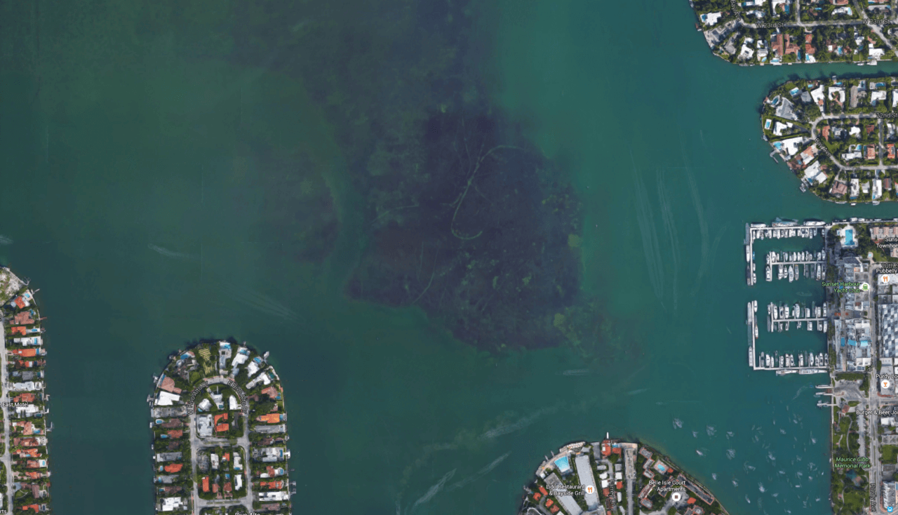
Fill deep borrow pits to reduce turbidity issues and promote the recolonization of seagrasses in the Bay.
Continue to preserve, protect, and mitigate mangrove, shoreline and wetland communities. Continue to remove and control exotic animals and vegetation.
Promote and provide educational programs about environmental concerns, and small boat handling and safety.
Continue to acquire and protect sensitive lands that are in direct proximity or directly impact the Bay, and enforce zoning regulations of other lands in the Bay area.
Continuation of monitoring of floral and faunal populations in the Bay, and strict enforcement of regulations designed to protect those resources.