The History of Bill Baggs Cape Florida State Park on Key Biscayne
I spend a lot of time exploring Bill Baggs Cape Florida State Park on Key Biscayne, and I have often wondered how it came to be what it is today.
Key Biscayne is notably the southernmost sand barrier island in the continental United States, and it has a really fantastic history going back thousands of years. The recorded history of Key Biscayne is one of the longest in North America, starting 500 years ago with the arrival of Juan Ponce de León. urrently, Key Biscayne is roughly divided into thirds, with the northern third being Crandon Park, the center being the Village of Key Biscayne, and the southern third being Bill Baggs Cape Florida State Park.
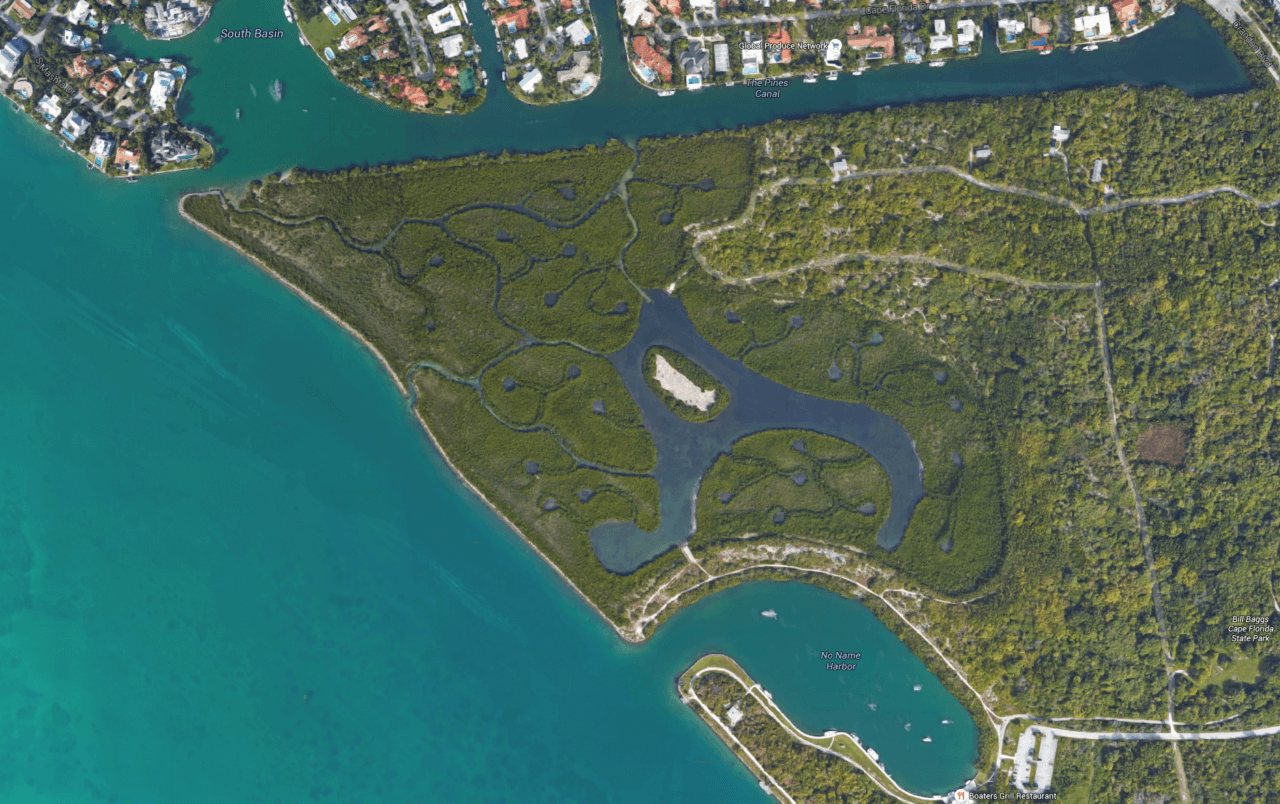
While I was exploring and researching Bill Baggs Cape Florida State Park over the past few years, it had always seemed odd to me that there were numerous roads, a harbor, and other unusual features for a state park. While looking at Bill Baggs Cape Florida State Park on Google Maps, I was struck by the very unusual shapes in the mangroves on the north-west corner of the park (see photo below), so I contacted the Art Levy at the park for an explanation of what created these mysterious shapes, and for the story on the history of the park. It turns out that the entire property was originally slated to be a huge housing development. Those amazing patterns in the mangroves were the impetus for this article.
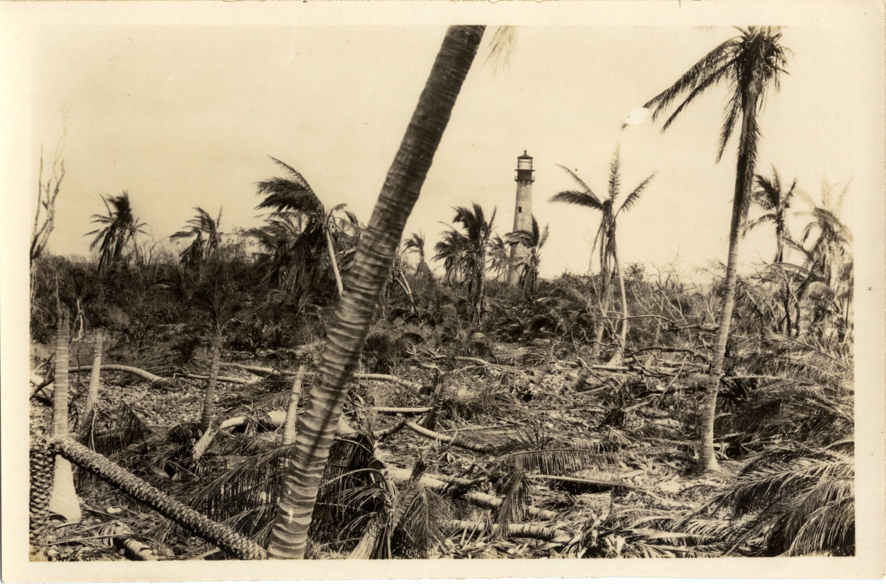
In the 1950’s, real estate developers were planning to build hotels, single family homes, and condominiums on the property that is today known as Bill Baggs Cape Florida State Park. The developers cut down every single tree on the entire property, including in the mangrove wetlands, and filled it all in with dredged material in order to level the property for development. At some point, the project stopped and invasive Australian Pine trees took root and dominated the area, much like you see on Virginia Key today. Bill Baggs, editor of the Miami News, strongly supported conservation efforts to rescue the southern section of Key Biscayne from development. Bill eventually convinced the owner to sell the property to the state for a park. Many years later, hurricane Andrew hit the park and destroyed most of the Australian Pines. After this fortuitous event, the State decided to restore the park to it’s 1950’s conditions, and the result is what we have today. Complete details on how this happened, and more, are below.
Cape Florida State Park Mangrove Wetlands Restoration
The strange features that you can see in the above photo are man-made canals and pools of water that are designed to help the mangrove restoration become successful. Drainage culverts were installed in the mangrove wetlands to allow tidal flushing, and mangroves were re-planted throughout the north-western tip of the park. The shapes that you see are excavations that allow the water from Biscayne Bay to penetrate and circulate to the roots of the mangroves.
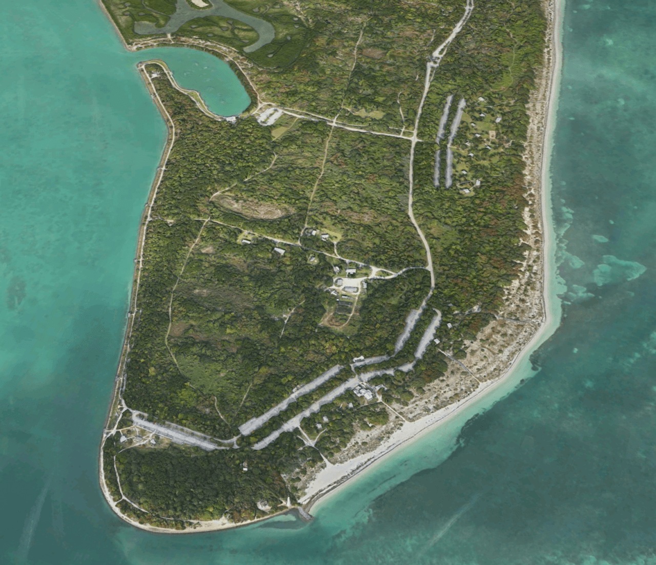
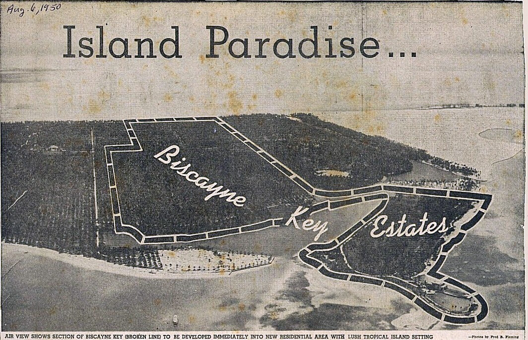
The above photo is how Bill Baggs Cape Florida State Park looks today. You can see the harbor, the roads, the paths, and the location of the Cape Florida Lighthouse on the southernmost tip. All of these features are clearly visible in the below rendering of the 1950’s real estate development project. The roads that were built to service the condominiums, hotels, and houses are now walking paths, bike paths, and the roads that service the park.

The Island Paradise – Rendering of the 1950’s Cape Florida Housing Development
I absolutely love the above photo. It completely clears up all of the questions that I’ve always had about why Bill Baggs Cape Florida State Park looks the way it does. It’s pretty remarkable how similar the layout of the park today is to this historic rendering of what it was supposed to have become! Compare it to the photo above it to see how today’s state park has the exact same layout as the original housing development.
The Mackle Company developed the middle of Key Biscayne in the 1950’s
In the above photo from 1950, you can very clearly see how the entire bottom 1/3 of Key Biscayne was clear-cut and then filled in with dredged sand. You can also see the Matheson coconut plantation in northern part of the island that was owned by the Matheson family, and the outline of The Mackle Company development, ‘Biscayne Key Estates’. This clear-cutting of the entire bottom of the island is what led to the invasion by the Australian Pine trees. On the far right of this photo is ‘Mashta House’ which just sold for $47 Million in 2015.
A (very) brief (but remarkably interesting) history of Key Biscayne:
- The Tequesta Indians (tuh-KES-tuh) lived throughout coastal south Florida, including Key Biscayne, for thousands of years. They had villages that were raised above sea level on posts cut from trees. They lived very successfully on the island’s seafood and native plants.
- In 1513, Juan Ponce de Leon “discovered” the island, naming it Santa Marta and claiming it for the King of Spain in 1513. The King of Spain granted the island to Pedro Fornelis, a native of Minorca.
- When Florida was traded to England in the mid-1700’s land was offered to encourage British Colonial plantations. Syndicates of investors were formed, and one was called the Cape Florida Society. But the era ended abruptly when Florida was traded back to Spain.
- In 1790, petitions were entertained for Royal Spanish land grants. The first issued in South Florida was for Key Biscayne, predating Key West.
- A London-born American woman made history by selling 3 acres of her property to the U.S. government for the Cape Florida lighthouse, built in 1825. Using the lighthouse compound as a central plaza, she and her husband planned the first town of Key Biscayne in 1839, offering 264 lots at $500 each.
- A succession of lighthouse keepers watched over the key. On July 23, 1836, Indians forced into South Florida by the Seminole Wars attacked and burned the Lighthouse and the caretaker’s home. The U.S. military built Fort Dallas next to the burnt out lighthouse in 1838. The fort included a hospital for the Army, Navy and Marines.
- The Davis family laid out the first town on Key Biscayne in 1839. A few lots were sold, but development was slow.
- Disputes about legal ownership of the Key were long-lived and made their way to the U.S. Supreme Court. James Deering, who had purchased the land from the Davis family, prevailed. Waters Davis repurchased the lighthouse and property from the U.S. Government in 1903 for $400.
- Early in the 20th Century, two-thirds of the island was established as a coconut plantation by the Matheson family, the largest in the continental United States. They were the original owners of the famous ‘Mashta House‘ that I wrote about in 2015.
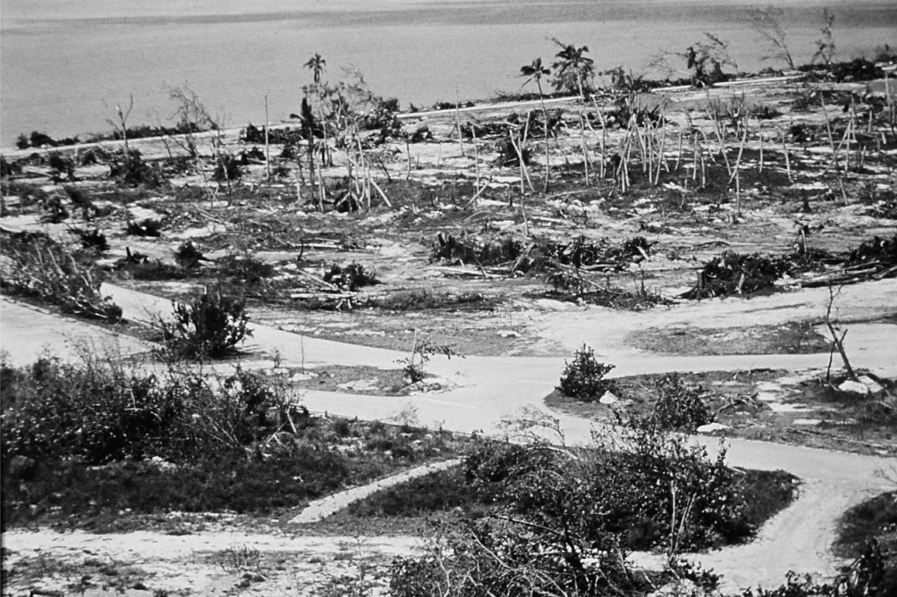
- The unnamed 1926 hurricane submerged the island as the eye passed directly over the Key, wiping out the coconut plantation.
- The Mathesons made a deal with Dade County, spearheaded by County Commissioner Charles Crandon, to donate the northern half of Key Biscayne to the public. In return, the County built a causeway to the Key from the mainland that was completed in 1947.
- José Áleman, a Cuban exile, bought Cape Florida (what is now Bill Baggs Cape Florida State Park) from James Deering in 1948. In 1949, a seawall was erected on the western and southern waterfront and the low-lying land filled with plans for development (see photo above).
- In 1951 The Mackle Company made a deal with José Áleman to purchase Cape Florida for $4,500,000 ($7,500 per acre). Áleman reneged on the deal and the Mackle Company chose not to pursue the matter in court.
- After Áleman died in 1951, his widow, Elena Santeiro Garcia, added to her Cape Florida property by buying an ocean-to-bay strip that had been part of the Matheson property. This strip included a canal that had been dug by William Matheson in the 1920s, and which extended from the bay across most of the island (visible in all of the above photos).
- In 1966 Bill Baggs, editor of The Miami News, was able to bring together Elena Santeiro Garcia with the State of Florida to purchase the land for the state park. Garcia sold the Cape Florida property in 1966 to the state of Florida. This land became Bill Baggs Cape Florida State Park, which opened January 1, 1967.
Cape Florida after the 1926 hurricane, with the Cape Florida Light in the background
Cape Florida State Park After Hurricane Andrew
The Bill Baggs Cape Florida State Park restoration project:
In the 1950’s over 200 acres of pristine wetlands on the south end of Key Biscayne, Florida were destroyed by the placement of over one million cubic yards of dredge fill from Biscayne Bay, and approximately two miles of concrete-lined shoreline. Those wetlands, which are essential to the general health of the coastal marine and estuarine ecosystem, were quickly taken over by a dry land forest of invasive exotic Australian pines (Casuarina equisetifolia). In 1992, Hurricane Andrew completely leveled the forest of invasive trees that dominated the area. In the aftermath of the storm, the Florida Department of Environmental Protection, Division of Parks and Recreation developed a draft conceptual recovery and restoration plan for the park. A major objective of the plan was to restore the historic vegetation types present on this portion of Key Biscayne prior to the destruction by the real estate developers. The vegetation types included beach dune, coastal strand, maritime hammock, interior isolated freshwater wetlands, and a large tract of tidally connected mangrove wetland in the northwest portion of the park. 85 acres of historical wetlands were restored at the park, through cooperative efforts of federal, state, and local agencies. The restoration plan involved the removal of exotics, removal of portions of the bulkhead and fill soil, placement of a protective lime-rock barrier, elevation grading, creation of isolated freshwater wetlands, tidal pools, flushing channels, and the planting of wetland vegetation.
The restoration plan was developed through the review of historical documents (1926 aerial photograph and personal observations), and field investigations of site characteristics. Field investigations included topographic, biological, geotechnical, hydrological, and archaeological reviews of the site. A comprehensive biological assessment was conducted, to document on-site and surrounding biological communities, to define biological goals and objectives, to identify environmental concerns, and to make specific recommendations concerning construction activities associated with the restoration. In addition, ground penetrating radar and electronic surveying were used to provide data on subsurface conditions. These evaluations were used to locate the five historically isolated wetlands that had been filled to 6.5 ft in the early 1950’s.
Wave energy, tidal regime, current velocity and bathymetry surveys were conducted to assist in the development of design components such as flushing canals (number, size, and depth), culverts (number, size, and elevation) and open water areas within the tidally connected wetlands. The final design was developed using the Dynamic Estuary Hydrodynamic Model, developed by the Environmental Protection Agency. Groundwater monitoring wells were installed one-year prior to the restoration, and were equipped with recorders to monitor seasonal fluctuations of groundwater. This was used to design elevations and contours of the five isolated freshwater wetlands which were restored in the park.
A two-phase archaeological monitoring plan, was conducted at the restoration site by a qualified archaeologist. Phase I included the evaluation of a series of trenches throughout the restoration area, and Phase II consisted of daily observations of the excavation work during the restoration process. Archaeological evaluation during the excavation phase of the project revealed a 1,000 year-old (B.P.) Human jawbone, along with an assortment of primitive conch shell tools. This is the oldest evidence of human habitation in this area.
Within 5 years of the restoration, a 100% survival of wetland species was realized. Wildlife observations conducted by FDEP, and local environmental groups documented an influx of fish and birds into the restoration area. More than 40 species of bird had been recorded using the saltwater wetlands and more than a dozen species of birds had been documented utilizing the freshwater wetlands.
The restoration of this area has been a fantastic success!
Map of Bill Baggs Cape Florida State Park:
Key Biscayne Condos & Homes For Sale:
Sorry we are experiencing system issues. Please try again.